Preferred Strategy
6. Sustainable Settlement Hierarchy
A key requirement for the Replacement LDP is to establish a Sustainable Settlement Hierarchy. The purpose of a Sustainable Settlement Hierarchy is to ensure that the right development takes place in the right locations with the best access to a wide range of services, facilities, and employment opportunities, whilst minimising car usage and the need to travel.
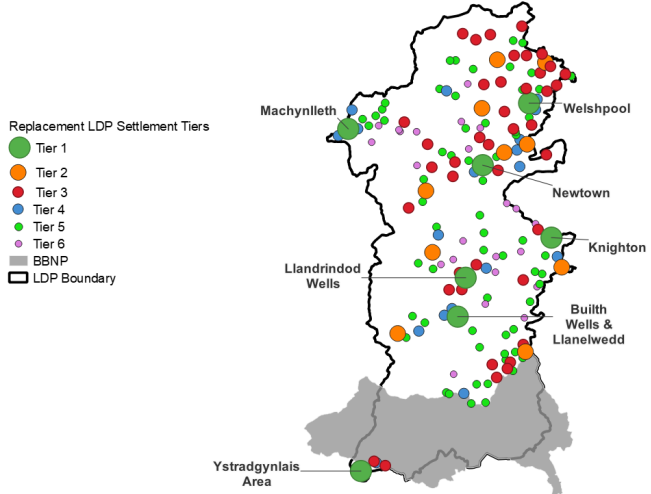
A settlement assessment has been undertaken to inform the Sustainable Settlement Hierarchy for the Replacement LDP. The assessment reviewed the sustainability, role and function of all the settlements identified in the Adopted Powys LDP (2011-2026) Settlement Hierarchy. In total 162 settlements were assessed and then categorised into six tiers, with the most sustainable Tier 1 settlements providing a wide range of services, employment and sustainable transport opportunities. The least sustainable settlements with limited access to services, employment and sustainable transport opportunities were categorised as Tier 6 settlements. Figure 5 shows the location and distribution of the Tier 1 to Tier 6 settlements across the Replacement LDP area.
Figure 5 - The Replacement LDP Sustainable Settlement Hierarchy
Considering the geographical clusters of settlements is an approach used to recognise the role, function and interaction between settlements at the plan level and local level.
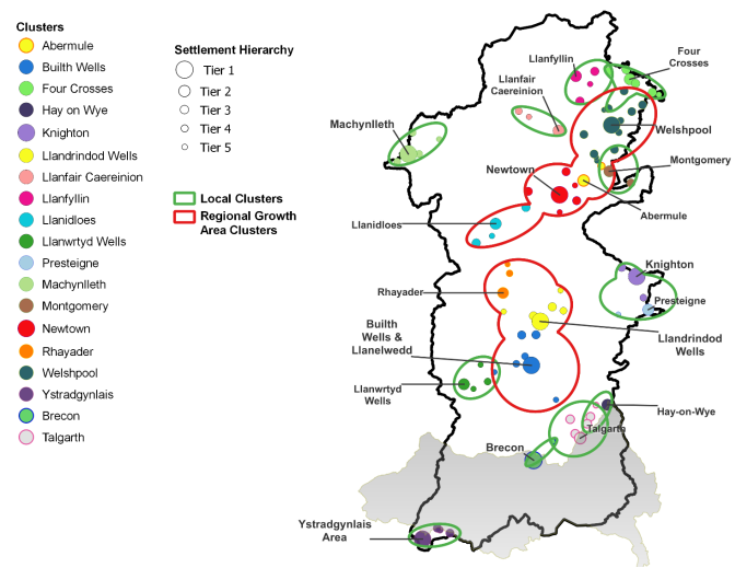
A Cluster Analysis, available as a background paper, was undertaken to identify settlement clusters across the plan area. The analysis identified functional relationships between Tier 1 and Tier 2 settlements, which act as service centres, and smaller neighbouring settlements using criteria that reflect the National Sustainable Placemaking Outcomes. In developing the cluster criteria, an emphasis was placed on promoting sustainable transport opportunities and the concept of 'living locally' in a rural authority.
The identified Settlement Clusters were further categorised as either 'Regional Growth Area Clusters' or 'Local Clusters' to reflect the policies of Future Wales.
Tier 6 settlements and any other settlements which do not have a functional relationship with a Tier 1 or 2 settlement (a service centre), are excluded from the clusters. Consideration was also given in the analysis to service centres located in neighbouring authority areas which have a functional relationship with lower tier settlements located in the LDP area. This found that there are several Tier 3 settlements and one Tier 5 settlement that cluster with service centres located in the BBNP (i.e. Talgarth and Brecon).
Figure 6 shows the distribution of the Clusters and the location of the settlements within them.
Figure 6 - Replacement LDP Settlement Clusters
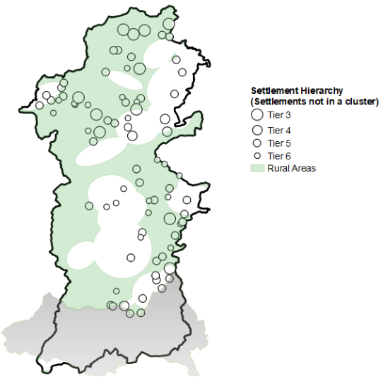
Future Wales requires LDPs to identify their rural communities in order to assess their needs and set out policies to support them. A Rural Approach background paper considered the best way for identifying rural communities and concluded that all settlements that lie outside of a Settlement Cluster should be considered as 'Rural'. Figure 7 shows the defined 'Rural Areas' and the 'Non-Cluster Settlements' to be treated as Rural by the Replacement LDP.
Figure 7 - Rural Areas and Non-Cluster Settlements
Powys' countryside is extensive and accommodates many isolated dwellings reflecting the County's agricultural and rural economy sector. The Replacement LDP area outside of the Tier 1 - Tier 6 settlements is defined as 'Open Countryside' and will be protected from inappropriate development.
Within the Replacement LDP area is an area of tidal influence near the Dyfi estuary, south-west of Machynlleth. This area is considered in national policy to be 'undeveloped coast.' For the purposes of the Replacement LDP any references to Open Countryside also include the undeveloped coast and will be protected from inappropriate development.
The following tables identify the Sustainable Settlement Hierarchy for the Regional Growth Area Clusters (Table 1), the Local Clusters (Table 2) and the Rural Area / Non-Cluster settlements (Table 3). Tier 1, 2 and 3 settlements are the most sustainable places for accommodating growth (all these settlements were classified as either Towns or Large Villages in the settlement hierarchy of the Adopted Powys LDP (2011-2026)). Lower tier settlements within a Regional Growth Area Cluster or Local Cluster, which have a functional relationship with a Tier 1 or Tier 2 settlement, may be able to accommodate limited growth in support of the higher tier settlement and to meet a recognised need.
Table 1. Regional Growth Area Cluster Settlement Hierarchy
Regional Growth Area Cluster Settlements
Tier 1
Builth Wells & Llanelwedd, Newtown, Llandrindod Wells, Welshpool
Tier 2
Abermule, Llanidloes, Rhayader
Tier 3
Arddleen, Berriew, Bettws Cedewain, Caersws, Castle Caereinion, Crossgates, Forden and Kingswood, Guilsfield, Howey, Kerry, Llandinam, Llangurig, Llanyre, Middletown, Newbridge on Wye, Trewern
Tier 4
Builth Road, Cilmery, Leighton Pentre, Penybont, St Harmon, Welshpool Buttington
Tier 5
Aberbechan, Cwmbelan, Dolfor, Erwood, Felinfach, Garth, Garthmyl, Groes-lwyd, Llandewi Ystradenni, Llanwrthwl, Pant y dwr, Refail
Table 2. Local Cluster Settlement Hierarchy
Local Cluster Settlements
Tier 1
Machynlleth, Knighton, Ystradgynlais Area
Tier 2
Hay-on-Wye, Four Crosses, Llanfair Caereinion, Llanfyllin, Llanwrtyd Wells, Montgomery, Presteigne
Tier 3
Abercrave, Boughrood & Llyswen, Bronllys, Churchstoke, Coelbren, Crew Green, Glasbury, Knucklas, Llandrinio, Llanfechain, Llansantffraid-ym-Mechain, Llanymynech, Meifod, Three Cocks
Tier 4
Caehopkin, Caerhowel, Derwenlas, Esgairgeiliog Ceinws, Llangadfan, Llangammarch Wells, Norton, Penegoes
Tier 5
Beulah, Bwlch-y-cibau, Cefn Gorwydd, Coedway, Glantwmyn, Kinnerton, Llanerfyl, Llowes
Table 3. Rural Area / Non-Cluster Settlement Hierarchy
Rural / Non-Cluster Settlement
Tier 3
Carno, Clyro, Llanbrynmair, Llangynog, Llanrhaeadr-ym-Mochnant, Llansilin, New Radnor, Penybontfawr, Pontrobert, Trefeglwys, Tregynon
Tier 4
Llanddew, Llandyssil, Sarn, Stepaside
Tier 5
Abercegir, Aberedw, Aberhafesp, Abertridwr, Adfa, Battle, Cemmaes, Clatter, Commins Coch, Cradoc, Cwm Linau, Cwmbach, Elan Village, Evenjobb, Ffynnon Gynydd, Foel, Forge, Frank's Bridge, Fron Bank, Gladestry, Groesffordd, Llanbadarn Fynydd, Llanbister, Llanfihangel, Llanfihangel Tal-y-llyn, Llanfilo, Llangedwyn, Llangunllo, Llanigon, Llanwddyn, Llanwnog, Llanwrin, Manafon, Painscastle, Pen-y-bont, Llanerch Emrys, Pool Quay, Rhosgoch, Sarnau (Mont), Tanhouse, Velindre (Brecknock), Walton, Whitton, Y Fan
Tier 6
Abbeycwmhir, Beguildy, Bleddfa, Bwlch-y-ffridd, Cefn Coch, Darowen, Dolanog, Dolau, Felindre, Hundred House, Llan, Llandegley, Llawr-y-glyn, Lloyney, Lower Chapel, Nantglas, Nantmel, New Mills, Newchurch, Old Radnor, Talerddig