Preferred Strategy
2. Powys Characteristics
2.1 Introduction
This section provides a general introduction to Powys and its characteristics and sets the context for the Replacement LDP.
2.2 Location and Topography
Powys is located centrally in Mid Wales and is geographically the largest authority in Wales covering approximately one quarter of Wales. It adjoins ten other LPAs, including eight in Wales and the counties of Herefordshire and Shropshire in England, as shown in Figure 1.
Figure 1 - Map of Powys and Neighbouring Local Authorities
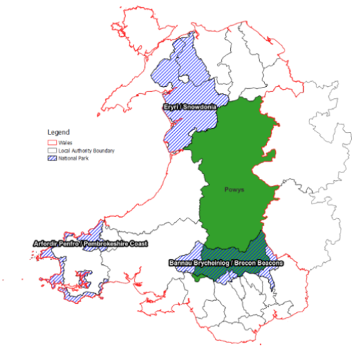
Powys is extensive in nature being a largely upland and very rural county covering over 5,000 square kilometres. In the south of the county is the BBNP, an LPA in its own right, which covers approximately 16% of the area of Powys. The Replacement LDP will need to take the BBNP and the Eryri National Park (to the north-west) into consideration as national landscape designations.
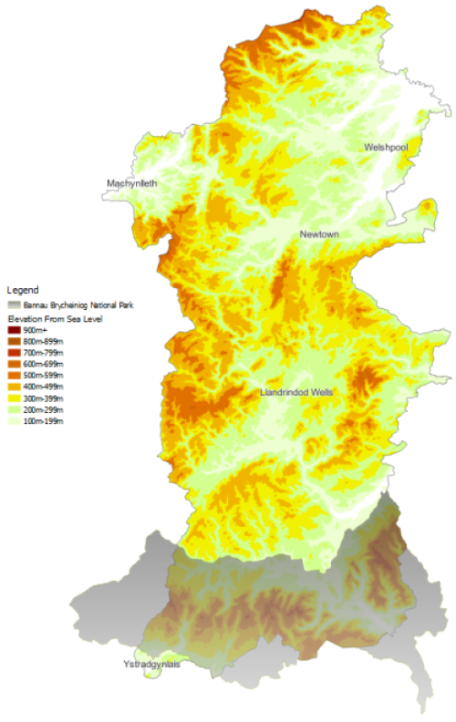
Figure 2 shows the topography of Powys and demonstrates how Powys is intersected with upland areas between the valleys. The upland areas include the Berwyns in the north, the Cambrian Mountains in the west, the Radnor Hills in the east and the Epynt in the south. The rivers dissecting the valley floors include the Severn, Vyrnwy, Tanat, Wye, Usk, Irfon, Ithon, Dyfi, Teme, Tawe and the Lugg.
Figure 2 - Map Showing the Topography of Powys
2.3 Settlements and Places
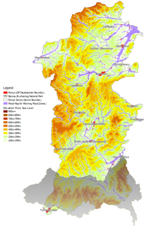
Powys' topography has meant that historically a large number of settlements and main transport routes are located in valleys at important river crossings and as a result of this a number of settlements are constrained by flood risk as shown in Figure 3.
Figure 3 - Main Settlements and River and Sea Flood Risk
In total, the Powys LPA area has 14 towns, only one of which, Newtown, has a population of over 10,000 people. It also has a number of villages and rural settlements along with more isolated dwellings located in open countryside. Varying levels of social and economic interaction take place between the settlements and with settlements outside of the Powys LPA area boundaries.
2.4 Environment
The architecture of Powys is as varied as its landscape, with most towns and settlements having distinct characteristics in building forms or settlements that make them easily recognisable. The rich wealth of architectural history ranges through all periods and all building types.
The quality of the historic environment is reflected in the large number of historic environment designations within the Powys LPA area. This comprises a total of 55 conservation areas, 10 registered historic landscapes, 37 registered parks and gardens, 3,938 listed buildings and 723 scheduled monuments.[1]
As a largely rural LPA, there is a wealth of biodiversity, geodiversity and conservation resources. A number of these are internationally and nationally recognised including 225 Sites of Special Scientific Interest, 13 Special Areas of Conservation, three Special Protection Areas, one RAMSAR site and nine National Nature Reserves. On a more local level, Powys has 105 Regionally Important Geodiversity Sites and 119 local wildlife sites.
2.5 Access and Transport
Powys has over 9,250 km of public rights of way. The main use of these rights of way is for recreation including walking, cycling and horse riding. In addition to this, Powys has 150,000 hectares (579 square miles) of open access land representing 29% of the land in Powys. Powys has two national trails, the Offa's Dyke Path and Glyndwr's Way. The Offa's Dyke path is 285 km (177 miles) long, of which 72 km (45 miles) falls within the county of Powys. In addition to the two national trails, Powys has several regionally important promoted trails including the Wye Valley Walk, Severn Way, Ann Griffiths Walk, Kerry Ridgeway, Pererindod Melangell and the Epynt Way.
Powys covers an area of around 5,195 km² and has a total road length of 5,511 km (15.7% of all roads in Wales).[2] As a predominately rural county, there is a high percentage of car ownership, although larger settlements have a lower proportion of car ownership, for example Welshpool.
Powys has the highest proportion of trunk roads in Wales, accounting for 27.3% of Wales' trunk roads.[3] Due to the location of Powys, set in the heart of Wales, most traffic travelling to or from the coast generally needs to drive through Powys. Some of these roads run through main settlements like Welshpool, Rhayader and Builth Wells, causing traffic disruption, particularly during holiday periods.
The Cambrian rail main line and the Heart of Wales rail line run through Powys, travelling between Aberystwyth and Birmingham International (Cambrian Mainline) and Shrewsbury to Swansea (Heart of Wales). These rail lines provide connections to not only the coast but also to major cities.
For most parts of Powys, public transport services are either absent or of limited frequency, with bus services linking up main towns and villages within and outside of the county. The Powys Well-being Assessment indicates that around half of Powys areas are in the worst 20% in Wales in terms of access to services.[4] In 2013, Powys had the highest proportion of population (28%) in England and Wales living in rural hamlets and isolated dwellings.
2.6 Population / Demographics
According to the Census, the population of Powys rose by 0.1% from around 133,000 in 2011 to around 133,200 in 2021. Based on the assumption that 18% of Powys's population resides within the BBNP, it is estimated that the population of Powys LPA area (excluding the BBNP) is 109,224 persons.
Powys has the lowest population density of all the local authorities in Wales at 26 persons per square kilometre.[5] A large proportion of the population lives in Towns (43%), as defined by the adopted LDP, 19% live in Large Villages, and 10% live in Small Villages and Rural Settlements. 28% of the population live in Open Countryside.
The components of change in the County's population over recent years have highlighted the fact that deaths have consistently exceeded births by a few hundred per annum. Migration both in and out, is the key determinant of change in the population size and structure. Recent trends in the population of the County over the last ten years have indicated an average net population gain. Despite this, Powys experiences a loss of young adults in their late teens through to their early 20s. Reasons for the loss of this element of the population generally include school leavers in search of further education, and young people looking for employment opportunities and affordable housing.
According to the 2021 Census, 15.5% of the Powys population were children aged 0 to 15, 56.6% were aged 15 to 64 and 27.8% were aged 65 or above. It is projected that the number of persons of working age will continue to decline. Meanwhile the number of persons over retirement age will increase. This means that the workforce will be a smaller proportion of the total population and that the old age dependency ratio (non-workers to workers) will increase.
2.7 Dwellings / Homes
The total number of households in Powys according to the 2021 census was 60,182 households, with an average household size of 2.19 people. It is estimated that 49,349 of these households were within the Powys LPA area, with around 10,833 living inside the BBNP.
Welsh Government higher variant household projections predict that the number of households in Powys (excluding the BBNP) will increase by 3.9% during the period of 2022 to 2037. This equates to an increase of 1,931 households during the Replacement LDP plan period.
In March 2022, it was estimated that there were 67,100 dwellings in Powys. 47,200 were owner-occupied, 11,300 were privately rented, 5,200 were owned by Powys County Council and 3,400 were owned by Registered Social Landlords.[6]
During the monitoring period of 1st April 2022 to 31st March 2023, a total of 339 dwellings were completed, which is a sustained improvement on the early years of the adopted Plan period.[7]
During the monitoring period of 1st April 2022 to 31st March 2023, a total of 124 affordable dwellings were completed, which means that the adopted Powys LDP (2011-2026) is on track to deliver the Plan's affordable housing target.[8]
The Local Housing Market Assessment (LHMA) 2024 identifies the level of housing need for both open market and affordable dwellings for Powys and also for 13 Housing Market Areas at the local level. Based on the assessment, there is a need for 1,646 market dwellings and 1,036 affordable dwellings, totalling 2,682 dwellings over the plan period for the Powys LPA area. The greatest overall housing need is in the Welshpool and Montgomery Housing Market Area. In terms of social rented housing, the greatest need is for one and two-bedroom properties which reflects the trend towards smaller household sizes.
2.8 Welsh Language
According to the 2021 Census, there were 21,359 Welsh speakers in Powys, representing 16.4% of the whole population. At the time of the 2011 Census, the percentage of Welsh speakers was 18.6%. Therefore, there has been a decline in the Welsh speaking population in Powys. Powys remains ranked as the local authority in Wales with the eighth highest percentage of Welsh speakers aged three years and over. According to 2021 Census data, 25% of Powys residents have some combination of Welsh language skills. Notably, the highest densities of Welsh speakers are found in the north and south-west of the County.
2.9 Economy / Jobs
With its sparsely populated upland landscape and poor connectivity, Powys has very few large employers (i.e. businesses with 250+ employees) outside the public sector. 31.3% of those in employment in Powys are self-employed, whereas the average percentage of self-employed employees in Wales is 12.2%. Likewise, the percentage in part-time employment in Powys is 32.2% which is higher than the 26.4% in part-time employment in Wales.[9]
Tourism acts as a cornerstone in supporting the local economy, attracting visitors with the beauty, remoteness and tranquillity of the landscape together with the cultural, agricultural, heritage and outdoor leisure opportunities.
Aside from tourism, agriculture, which is predominantly through small family-run upland sheep farms, is also a key pillar of the local economy. Farming and forestry have shaped the landscape, culture and people of Powys for many generations. In 2020, there were 4,935 agricultural holdings in Powys which was a fifth of the holdings in Wales. There were 6,900 workers working in the industry of agriculture, forestry and fishing in 2022.[10]
The three largest employment sectors in Powys by percentage of jobs were public administration, education and health (31%), distribution, hotel and restaurant (17%), and banking, finance and insurance (13%).[11]
Drawing on data provided by the ONS, 2.3% of people aged 16 to 64 years in Powys were claiming unemployment-related benefits in March 2024. 22.1% of the population aged 16 to 64 were economically active in Powys compared to 23% across Wales.[12]
2.10 Retail, Recreation and Leisure
Within Powys the level and type of provision for recreational and leisure activities varies across the county. Formal, organised activities are mainly located within the main towns and larger settlements. There are currently 16 leisure centres across Powys including those in the BBNP.
Retail provision in Powys is focussed upon its historic towns. Newtown, as a sub-regional centre, has the largest and most varied shopping facilities of the Powys LPA area. The area has five primary towns, namely Welshpool, Llanidloes, Llandrindod Wells, Machynlleth and Builth Wells, serving large spatial areas and meeting the needs for shopping and local services not met within secondary and local towns. The secondary towns of Rhayader, Knighton, Ystradgynlais and Presteigne are of smaller scale and have smaller local catchments typically meeting local needs with some specialised provision. This hierarchy is supplemented by local towns which may provide essential items required to meet day to day needs, including Llanfyllin, Montgomery, Llanfair Caereinion and Llanwrtyd Wells.
For residents living in the rural areas of the County, their daily lives rely highly on local retail facilities such as village shops, sub-post offices, public houses and farm shops, which are important in supporting the vitality and viability of rural villages, providing easy access to basic provisions (especially for those with limited mobility).
[5] Wellbeing Information Bank: View information about Powys population density - Powys County Council
[10] Wellbeing Information Bank: View information about Employment by industry - Powys County Council, 22-47-farming-sector-in-wales.pdf (senedd.wales)